Lane County’s thunderous waterfalls are truly a sight to be seen—and you don’t have to go far to find one. Drive, hike, or bike in any direction from Eugene and enjoy dozens of waterfalls right by the roadside. Most are close to area highways, making it easy to spend the day or an entire weekend exploring the diverse ecosystems therein. Hike amidst the old-growth and ancient lava beds at Proxy Falls, or bike to see Oregon’s second-tallest waterfall, Salt Creek Falls just up the hill from Oakridge. From Cascades to Coast, Lane County’s waterfall adventure begins here with a brief guide to our favorites.
Brice Creek Falls
Brice Creek Road in Cottage Grove
The Brice Creek corridor is a scenic, rocky canyon with numerous small waterfalls and pools in the creek. The .3 mile (.5 km) wheelchair-accessible trail from Cedar Campground is rated moderately difficult for wheelchairs and easy for hikers.
Diamond Creek Falls
East of milepost 58 on Highway 58 in Oakridge
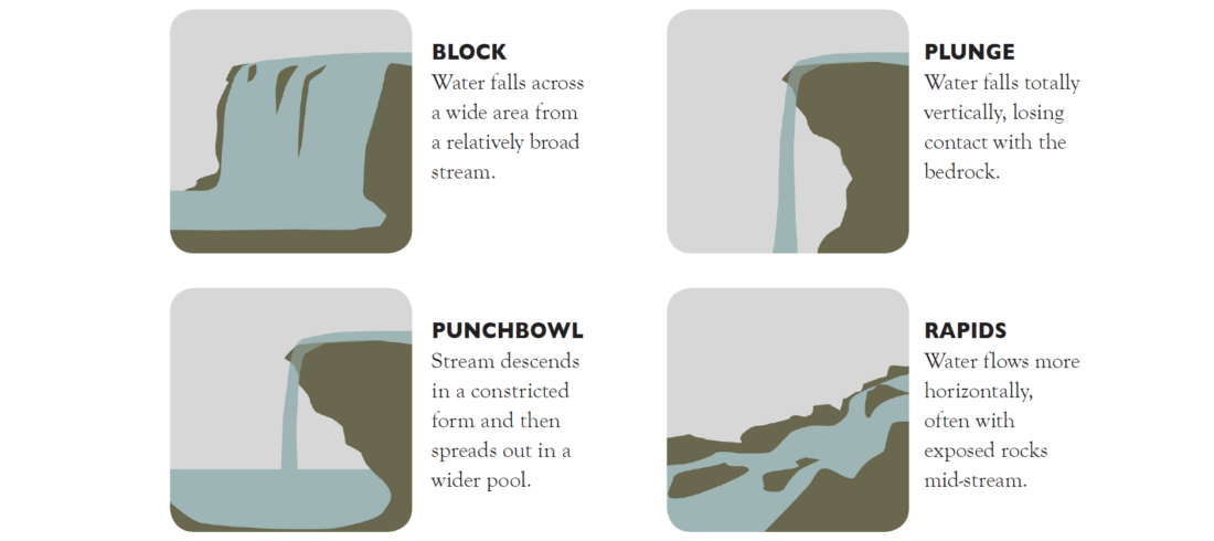
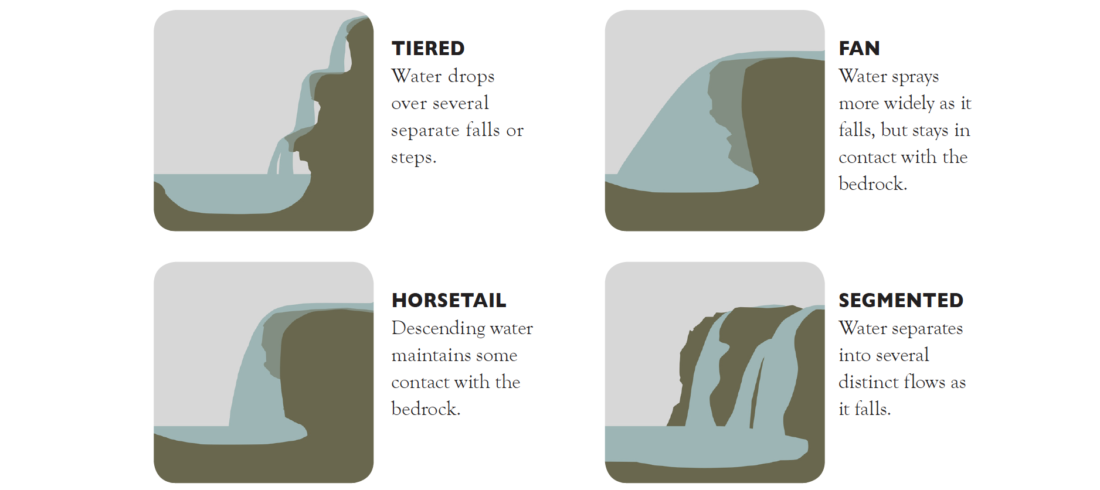
Fan shaped Diamond Creek Falls drops 90 feet and its tiered lower falls drop 200 feet. To view the falls follow Diamond Creek Falls Trail #3598 from the Salt Creek Falls Observation Site.
Salt Creek Falls
About 6 miles west of Willamette Pass at Milepost 58 in Oakridge
Day Use Fee Area/Northwest Forest Pass. Oregon’s second-highest waterfall, Salt Creek Falls is a popular place for visitors to explore. Viewing platforms are wheelchair-accessible and allow sightseers to view the entire 286-foot plunge of Salt Creek.
Koosah Falls
Highway 126, 18 miles east of McKenzie Bridge
Koosah plunges 100 feet over an abrupt lava outcropping to a small pool below. Take Highway 126, turn left at Ice Cap Campground then continue to the small parking area.

Proxy Falls
Highway 242, Near milepost 64 outside McKenzie Bridge
Day Use Fee Area/Northwest Forest Pass. Wind along the 1.4 mile loop trail through ancient lava fields and dense forest to view two separate 100+ foot (30.5 m) tiered and segmented cascading falls.
Sahalie Falls
Highway 126, 18 miles east of McKenzie Bridge
Sahalie plunges 100 feet through basalt boulders and then tumbles 40 feet in a series of mossy cascades. The Sahalie Falls viewpoint is a wheelchair accessible paved trail with railings.
Sweet Creek Falls
Sweet Creek Road in Mapleton
At Siuslaw bridge in Mapleton, take highway 126 and go south on Sweet Creek Road. An 11 mile drive will take you to the first trailhead and 11 waterfalls of every variety. Parking at each trailhead.
Trestle Creek Falls
Brice Creek Road–Park before the bridge at Brice/Champion Creek Trailhead, Cottage Grove
This scenic 60-foot waterfall is nestled in a moss-covered grotto surrounded by towering old-growth forest. A moderate .6 mile trail offers a great family hike. About 46 miles south of Eugene.
Wildwood Falls
Lower Brice Creek Road, Cottage Grove
The Row River has incised a few channels in the small basalt cliff creating the falls, and thusly forming 3-4 different segments. On sunny days, you’ll likely see local swimmers in the deep pool below the falls.
Salmon Creek Falls
4 Miles east of Oakridge Rd. 24, Oakridge
Salmon Creek Falls is a small 5-10 foot drop in the creek. Kayakers can play around in the waves by the day use area or paddle the mile-long gorge upstream. This run culminates with a drop over Salmon Falls and can be combined with the five-mile class III section below the falls. Take Highway 58 to Salmon Creek Hatchery Road at Oakridge, and then turn right on Salmon Creek Rd.
Kentucky Falls
Forest service road 919 outside of Mapleton
Kentucky’s 90 foot twin waterfalls pour over a cliff surrounded by Doug Fir and Western Hemlock giants. From Hwy 126, about 12.5 miles east of Mapleton, turn south onto county road 4390 (Siuslaw River Road). Go 1.5 miles and bear right across the bridge. In 1.5 miles turn left uphill onto Dunn Ridge Road. Travel 6.9 miles bearing left at the end of the pavement. Bear right at the three-way intersection. In 2.7 miles turn right onto Forest Service Road 919. Follow signs to the trailhead, which is within 2.5 miles.
Types of Waterfalls


